Normalized Difference Vegetation Index (NDVI)
The plant is characterized by others reversing a little amount of red rays and reversing a large amount of near-infrared. Therefore, it can link the biomass of plants to the values of the vegetative guide, which calculates the proportionality of the infrared range and the infrared range close to the following equation.
NDVI= (NIR – RED ) / (NIR + RED)
NDVI: Normalized Difference Vegetation Index: NDVI
NIR : Infrared ray: NIR
Red ray : RED
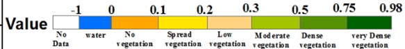
Indicate on the Green cover guide values range from (-0.1 – 1.0) Negative values refer to clouds and water, positive values near zero refer to barren soil, and higher positive values for:
(0.1-0.2) : Spread vegetation
(0.2-0.3) : Low vegetation
(0.3-0.5) : Moderate vegetation
(0.5-0.75) : Dense vegetation
(0.75-1.0) : Very dense vegetation
To download the maps, press the button below:/span>
![]()
Source:
https://earthexplorer.usgs.gov/